
San Ysidro's early urban development came from a visionary group of people who came to settle in the valley in 1909 and founded an agricultural utopian colony called "Little Landers." This group of people, in communion with their Mexican neighbors appropriately, christened their community with the name of the patron saint of farmers, ISIDRO, "a virtuous farmer who had fallen asleep and had his fields plowed for him by angels."
Varrio San Ysidro aka “SIDRO” from the community which carries the same name is located in the southern most part of the City of San Diego, adjacent to the international border with Tijuana (Tijuas) Baja Califas.
San Ysidro is a community that is both a small town and bustling city; a gateway between Mexico and Califas. More than a century of settlement and development makes San Ysidro a changing community, yet one which still retains a small neighborhood atmosphere. Many architectural and cultural qualities from different periods of its evolving history have been retained and are captured in this neighborhood. San Ysidro began as an agricultural experiment to preserve a rural agricultural/farm lifestyle, but now has emerged as a multicultural area attempting to maintain its sense of community. Some areas of the Barrio are characterized by a lot of empty lots and real viejo homes with well-tended gardens where las familias know their vecinos, while newer urban tracts of homes and ever increasing apartment complexes continue to add into the mix of residents.
El barrio de San Ysidro is bounded in the east by the hills and canyons below Otay Mesa. To the west is the Tijuana River Valley, a vast wetlands area that reaches as far west to the Pacific Ocean. To the south is the International border; Tijuana on the other side of La Linea (The Fence). Bordering on the north side is the 905 Freeway which separates Sidro from the communities of Palm City and Del Sol (Otay-Mesa West). These natural and man-made boundaries have served the Barrio well over time in helping it to keep its unique identity; however the cohesion of this community over the decades, has been fragmented by the construction of Interstates (5), (805), (905) and the San Diego Trolley.
San Ysidro’s Mexican roots and ties with Tijuana have from the onset been real strong. There can never be any question about the ties-that-bond both sides of the border in this here town. From its early history of ranchos and farms, to the turn of the century Little Landers Colony experiment; continuing thru the 1920’s and onto the 1930’s when Mexicans began to increase dramatically in numbers and into the 1940s when Sidro became the gateway to the bustling party town of Tijuas. Tijuana with its nightlife, its gambling, its racetrack and oceanfront beaches, attracted more than a just few people from American & Californian society. Among the throngs of people coming down to party-hardy, so too entered the Pachucos and they introduced their Gangster stilo. These Chucos --Tarzanes as they were called down on the Mexican Side, so much influenced the young jente in Tijuas, that their style survived even up to the late 60s/early 70s. In San Ysidro -which back then was almost like an extension of Tijuana's Colonia Libertad- the pachucos left their impact as well, and the Young Raza from Sidro being no different than everyone else in the barrios of Califas, they cliqued up under the pachuco style and created their own Pachuco Club.
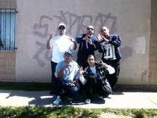
The “COACHMEN” the first clika from SIDRO.
The Coachmen began their life as an un-official car-club in the very early 1950s. The Barrio in those days was very much all-along San Ysidro Blvd. in particular, further to the west side --west of today’s 805 freeway-- stretching all the way to Dairy Mart Road. The COACHMEN cruised with their coches (ranflas) all up and down LA VILLA as the strip was called in-between Via de San Ysidro and Dairy Mart Road. Most of the neighborhood Vatos (some 50 in those days) worked and kicked it at the empacadoras (the packing plants) also on the strip, over by where SY Blvd and Dairy Mart Road meet. By the late 50s, these Vatos had become straight-up a “VARRIO” in all sense of the meaning, and at the start of the 60s, their second generation “Los ENANOS” took their place.
During the 1950/60s, the population increased big time and the Barrio kept growing. Soon, the slicing up of the community began. The construction of Interstate 5 cut off Calle Primera and the southern part of the old neighborhood, splicing it off from the rest of the community.
Then in 1964, the 805 spliced it up again right down the middle, creating what today is called East & West SY Blvd; thus, cutting off the oldest part of the neighborhood straddling the Rail Road tracks closest to La Colonia Libertad of Tijuana.
Businesses and new housing development sprang up everywhere. The southern part of the neighborhood, south of Calle Primera, became a smugglers paradise. Laying right next to the then wide-open countryside and swamplands --next to the then still non-built Tijuana River-levee-- and the dairy's/horse ranches below the pristine hillsides, canyons and ravines in the notorious “Badlands." This whole area became the most contested grounds between La Migra & La Raza ever; all up to the time when Operation Gatekeeper built up their border protection system of cameras, motion sensors and La Tortillera (the ugliest-looking sheet-metal high-fence ever built).
The tract along Camino De La Plaza was built up with commercial malls and the Park Haven Apartment complex came to existence in-between those shopping plazas and Larson Field --later re-named Cesar Chavez Community Center. The Park Haven Apartment complex still stands today. A two block low-income housing place that was notoriously known as the half-way houses between runs across the Badlands.
On the north side of the I-5, the Barrio continued to grow around the Library and Community Center located on East & West Park Ave. This area became the heart of the Barrio and remains so onto these present times. It is in this turf that the next generations of SY clikas sprung-up in the 1970s.
The 70s saw an explosion in Raza. Crowds of Raza were everywhere. Up by the hills above Beyer Blvd over by Del Sur Blvd, the VILLA NUEVA apartment complex was built in 1970. The residents who had been displaced by the never-ending build-up and re-development, were given first crack at the units. This place has all the looks of a typical housing-projects complex, and back in the 70s, La Raza in these grounds got together and formed the clika VILLA LOCOS.
The VLS kicked it at THE LANE --present day Athey Ave.-- at the Vista Terrace Park overlooking the ravine running along the then 117 Highway --which later became the 905 Fwy. This ravine was semi-wild country and it separates Sidro from Varrio Del Sol on the other side of the road.
When the 905 was built in 1975 along this same route, it broke-off another chunk of SY to the northwest along Iris Avenue. This area around Southwest Junior H.S. gave birth for a short-stint to the VARRIO IRIS AVENUE (VIA).
During the mid-to-late 70s, the LOCOTES clika sprung up in the Park Ave neighborhood. During this time-era, the Surfo (Stoner) stilos came of age on both sides of The Fence. Cholo & Surfo gangs exploded in Tijuas, and in San Ysidro the young crowds of Raza, --which many have always kept up ties with families south of the border—their Surfo counterparts also staked claim to hang-out spots in Sidro. The SY PUNKS surfaced during these years; then LOS BIKERS (both Surfo crowds). The SY Punks gradually fell in-line with the Cholo stile and joined up with SYR. Los Bikers used to hang around where today’s Beyer Blvd Trolley Station exist today on Beyer and Cottonwood Road. They adopted their name from the simple fact that their members all had those old-school 16 inch spoke wheels bikes. At the turn of the 80s when the Trolley system was built in 1981, their spot was razed and with the Surfo stile becoming a dying breed, it didn’t take long for them to disappear from the scene. Nevertheless, some from Los Bikers joined the main SY ranks.
With the arrival of the 80s decade, new clikas were formed.
In the mid-80's the SY GANGSTERS formed up and kicked it at The Alley (Cypress Dr.) behind West Park Ave in the street-alley where it meets up with Blanche Street.
The LOCOTES clika continued-on, but they took up a spot further north on Cypress, up the next block where it dead ends with the Trolley tracks.
The VILLA LOCOS continued staying up as well, but their numbers were greater on the north side of the tracks.
By the mid-to-late 80s, the LIL LOCOS clika sprang up, sponsored by the LOCOTES, and then the TINY LOCOS, followed up by Los MALOS in the 1990s.
By the 1990s, all the SYR clikas were inter-mixed. They kicked it here there and everywhere. The MALOS began to make more of presence on the south side of the 5 Freeway over by Sycamore/Larsen Field as well as the LOCOTES. The TINY LOCOS remained closer to the center of the Barrio along the community center, even so, all the clikas continue to hang-out together.
Hitting the mid-decade of this new millennia, a new clika is on the making; youngsters calling themselves “BOYS,” but they’re yet to be confirmed, last heard of.
This History of VARRIO SAN YSIDRO is one pieced together here and there, therefore if I’m off on some or anyone can share better info, by all means
~~> spit it out.
“I’m more than interested” . . .
By LONEWOLF


